
I was looking for a geologic map of Rattlesnake ridge, which I didn't find. I did find this one of a study farther north. In the lower corner is a map that does show faults & folds on Ahtanum and Rattlesnake. I think it's interesting that one of those faults, to this layman's eye, looks to be where it is spreading.
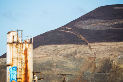
The photo I've attached is likely taken from the Parker post office parking lot. I haven't walked down there to be certain but that ugly tower in the foreground is across the highway from Parker. The top of the ridge was in the fog yesterday and so far still is this morning so I can't actually see anything.

Pacific Northwest Seismic Network article on the landslide, with bonus appearance by trains. (Making an interesting Venn diagram of Effie's interests!)
https://pnsn.org/blog/2017/12/30/seismic-monitoring-of-a-slow-landslide
On Sun, Jan 7, 2018 at 11:32 AM Effie in the desert wadesert@hotmail.com wrote:
I was looking for a geologic map of Rattlesnake ridge, which I didn't find. I did find this one of a study farther north. In the lower corner is a map that does show faults & folds on Ahtanum and Rattlesnake. I think it's interesting that one of those faults, to this layman's eye, looks to be where it is spreading.
The photo I've attached is likely taken from the Parker post office parking lot. I haven't walked down there to be certain but that ugly tower in the foreground is across the highway from Parker. The top of the ridge was in the fog yesterday and so far still is this morning so I can't actually see anything.
https://pubs.usgs.gov/sim/3212/sim3212_sheet.pdf
UTS mailing list UTS@starmanet.com http://starmanet.com/mailman/listinfo/uts_starmanet.com
Not to mention the Ag museum sits at the base of Ahtanum Ridge which is actually the western extension of the same anticline. Then as I've said before my house within sight of the crack. It's all definitely in my ballpark!
________________________________ From: UTS uts-bounces@starmanet.com on behalf of Bruce Jividen kundar@gmail.com Sent: Tuesday, January 9, 2018 12:21 PM To: Under the Stars Subject: Re: [UTS] Geo map
Pacific Northwest Seismic Network article on the landslide, with bonus appearance by trains. (Making an interesting Venn diagram of Effie's interests!)
https://pnsn.org/blog/2017/12/30/seismic-monitoring-of-a-slow-landslide
On Sun, Jan 7, 2018 at 11:32 AM Effie in the desert <wadesert@hotmail.commailto:wadesert@hotmail.com> wrote:
I was looking for a geologic map of Rattlesnake ridge, which I didn't find. I did find this one of a study farther north. In the lower corner is a map that does show faults & folds on Ahtanum and Rattlesnake. I think it's interesting that one of those faults, to this layman's eye, looks to be where it is spreading.
The photo I've attached is likely taken from the Parker post office parking lot. I haven't walked down there to be certain but that ugly tower in the foreground is across the highway from Parker. The top of the ridge was in the fog yesterday and so far still is this morning so I can't actually see anything.
https://pubs.usgs.gov/sim/3212/sim3212_sheet.pdf
_______________________________________________ UTS mailing list UTS@starmanet.commailto:UTS@starmanet.com http://starmanet.com/mailman/listinfo/uts_starmanet.com

Right behind home plate so to speak.
From: UTS [mailto:uts-bounces@starmanet.com] On Behalf Of Effie in the desert Sent: Tuesday, January 9, 2018 3:18 PM To: Under the Stars Subject: Re: [UTS] Geo map
Not to mention the Ag museum sits at the base of Ahtanum Ridge which is actually the western extension of the same anticline. Then as I've said before my house within sight of the crack. It's all definitely in my ballpark!
_____
From: UTS uts-bounces@starmanet.com on behalf of Bruce Jividen kundar@gmail.com Sent: Tuesday, January 9, 2018 12:21 PM To: Under the Stars Subject: Re: [UTS] Geo map
Pacific Northwest Seismic Network article on the landslide, with bonus appearance by trains. (Making an interesting Venn diagram of Effie's interests!)
https://pnsn.org/blog/2017/12/30/seismic-monitoring-of-a-slow-landslide
On Sun, Jan 7, 2018 at 11:32 AM Effie in the desert wadesert@hotmail.com wrote:
I was looking for a geologic map of Rattlesnake ridge, which I didn't find. I did find this one of a study farther north. In the lower corner is a map that does show faults & folds on Ahtanum and Rattlesnake. I think it's interesting that one of those faults, to this layman's eye, looks to be where it is spreading.
The photo I've attached is likely taken from the Parker post office parking lot. I haven't walked down there to be certain but that ugly tower in the foreground is across the highway from Parker. The top of the ridge was in the fog yesterday and so far still is this morning so I can't actually see anything.
https://pubs.usgs.gov/sim/3212/sim3212_sheet.pdf
_______________________________________________ UTS mailing list UTS@starmanet.com http://starmanet.com/mailman/listinfo/uts_starmanet.com
Look closely at the map in the link Bruce sent. Near the top is a green area labeled Fullbright Park. The white lines are the roads through the park and into the Ag museum. When I wrote the message yesterday saying I was at the base of Ahtanum ridge, you can see the location on this map. Where the road heads toward the ridge right below the "ll" in Fullbright is where the office sits - where I am on Tuesdays.
I really liked reading the comments in this post. Thanks Bruce for finding it. The image with the train trace was shown on one of the TV stations the other night. What I found very interesting in this post was that one of the permanent monitors hadn't been functional in a long time and suddenly it became important to fix. Simply more proof that anything on the east side of the state is low priority.
One macabre thought I've had relates to how the upper valley and lower valley are completely separate locations even though only a few miles apart. Those of us who live in the lower valley, i.e. anything south of Union Gap have always been treated as if we're behind a impenetrable concrete wall. Businesses and services from the upper valley won't come to the lower valley. We're expected to get services from Sunnyside - 35 miles south rather than Yakima - 12 miles north. If Rattlesnake Ridge were to fall off and block the gap (which under no circumstance will it do) we'd have a real wall.
Our governor visited Union Gap on Sunday. What good that did I can't imagine.
________________________________ From: UTS uts-bounces@starmanet.com on behalf of Chuck S chucksim@mindspring.com Sent: Tuesday, January 9, 2018 8:31 PM To: 'Under the Stars' Subject: Re: [UTS] Geo map
Right behind home plate so to speak.
From: UTS [mailto:uts-bounces@starmanet.com] On Behalf Of Effie in the desert Sent: Tuesday, January 9, 2018 3:18 PM To: Under the Stars Subject: Re: [UTS] Geo map
Not to mention the Ag museum sits at the base of Ahtanum Ridge which is actually the western extension of the same anticline. Then as I've said before my house within sight of the crack. It's all definitely in my ballpark!
________________________________
From: UTS <uts-bounces@starmanet.commailto:uts-bounces@starmanet.com> on behalf of Bruce Jividen <kundar@gmail.commailto:kundar@gmail.com> Sent: Tuesday, January 9, 2018 12:21 PM To: Under the Stars Subject: Re: [UTS] Geo map
Pacific Northwest Seismic Network article on the landslide, with bonus appearance by trains. (Making an interesting Venn diagram of Effie's interests!)
https://pnsn.org/blog/2017/12/30/seismic-monitoring-of-a-slow-landslide
On Sun, Jan 7, 2018 at 11:32 AM Effie in the desert <wadesert@hotmail.commailto:wadesert@hotmail.com> wrote:
I was looking for a geologic map of Rattlesnake ridge, which I didn't find. I did find this one of a study farther north. In the lower corner is a map that does show faults & folds on Ahtanum and Rattlesnake. I think it's interesting that one of those faults, to this layman's eye, looks to be where it is spreading.
The photo I've attached is likely taken from the Parker post office parking lot. I haven't walked down there to be certain but that ugly tower in the foreground is across the highway from Parker. The top of the ridge was in the fog yesterday and so far still is this morning so I can't actually see anything.
https://pubs.usgs.gov/sim/3212/sim3212_sheet.pdf
_______________________________________________ UTS mailing list UTS@starmanet.commailto:UTS@starmanet.com http://starmanet.com/mailman/listinfo/uts_starmanet.com
-
 Bruce Jividen
 -
 Chuck S
 -
 Effie in the desert